Linking Nature and History: The Frederick G. Todd Landscape Plan (Part 2)
Cap Diamant, the Martello Towers, the astronomical observatory and the Québec Prison
L'exploration of the site that would eventually become Battlefields Park continues in this second post of a three-part series.
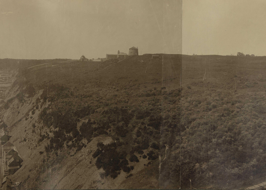
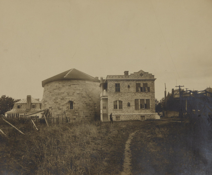
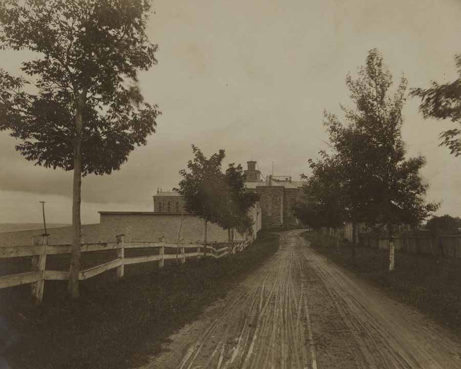
The plan landscape architect Frederick G. Todd envisioned for the park back in 1909 came with photographs. We trace his steps to get a clearer sense of his vision. After exploring the park’s eastern sector—around the Quebec Skating Rink, the Québec City fortifications and Cove Fields—we move on toward Cap Diamant before heading west, home to the Martello Towers, the astronomical observatory and the Québec Prison.
Cap Diamant
The famous headland jutting out toward the St. Lawrence River, Cap Diamant is now home to parts of Old Québec City, the Citadel and a section of the Plains of Abraham. Centuries ago, it captured the imagination of the first European explorers.
They dreamed mostly of striking gold or discovering diamond deposits in the cliffs along the St. Lawrence. Jacques Cartier was the first to bring stones back to France, convinced he had found precious minerals. His misadventure gave rise to the French expression “faux comme des diamants du Canada” (meaning “as fake as Canadian diamonds”), since the stones turned out to be nothing more than quartz. Samuel de Champlain also thought he had struck diamonds in the cliffs, but was no luckier.
Even so, these early missteps likely gave Cap Diamant its name, as it began appearing on maps of the city and region in the second half of the 17th century.
Todd was quick to notice Cap-Diamant and the possibilities it offered for the future Battlefields Park, particularly for its sweeping, magnificent views of the region. In his landscape plan, he fully intended to leverage the cape’s natural contours by creating a scenic drive, known today as Cap-aux-Diamants Avenue.
DRIVE NO. 2 At a short distance from the Main Entrance this drive branches off from Drive No. 1 and ascending gradually the ruins of the covered way forming part of the old fortifications constructed by the English Army [NOTE: Temporary Citadel], reaches a high point known as Cape Diamond. From this point are obtained perhaps the finest and most impressive views of any of the whole park. The view up the river, partially shown in Photograph No. 7, is particularly fine.
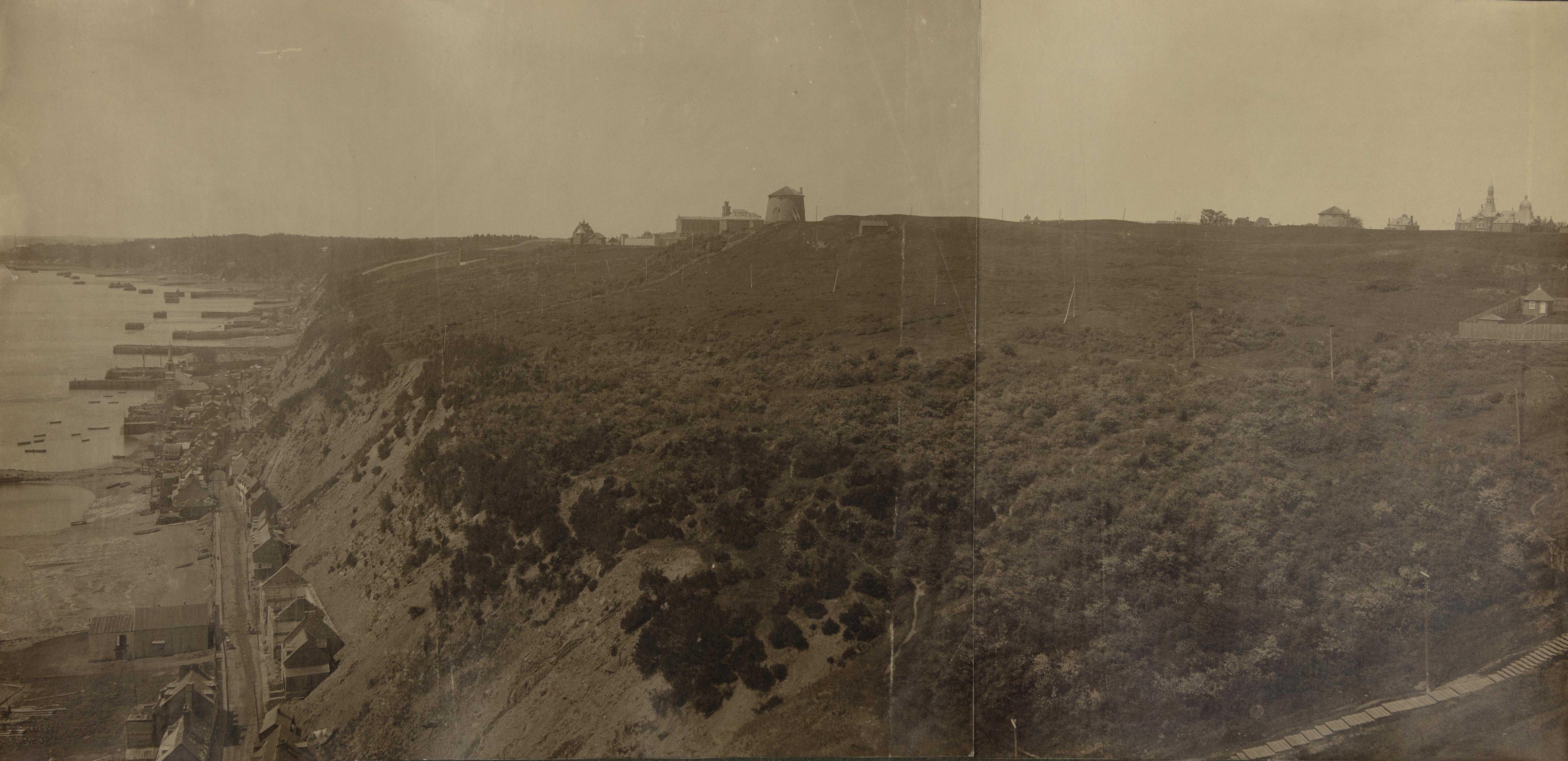
The photograph accompanying Todd’s plan reveals a view of the rest of the future park. It appears as a blank canvas waiting to be shaped, with no roads and very few trees or bushes. Everything was still yet to come. Of course, a few buildings were already scattered across the site. In the foreground stands the staircase leading down to Champlain Street along the river, known today as the Cap-Blanc Stairs. This entire waterfront neighbourhood was then dominated by Notre-Dame-de-la-Garde church and numerous piers. Its residents still lived to the rhythm of the timber trade, though it was in decline. Just behind, the fence enclosing part of the Dominion Arsenal complex (on the right) also points to the presence of heavy industry. Two Martello Towers are clearly visible as well.
Martello Tower 2, farther to the right, sits on the edge of what would become Battlefields Park and marks roughly the boundary Todd had envisioned for the park. To its right stands the Franciscan Sisters Missionaries of Mary Monastery, today integrated into a residential building on Grande Allée. Martello Tower 1, right in the centre of the photo, sits atop the promontory. Perspective can be deceiving, however: the Québec Prison, to the left of the tower, and the astronomical observatory, which look quite close, are actually a few hundred metres farther west. Todd saw these buildings as obstacles to realizing his vision:
In the end, however, the architect sought to protect the Martello Towers and integrate them into his plan.
The Martello Towers
In the early 19th century, military engineer Gother Mann devised a defence plan for Québec City. Among the various measures proposed to protect the city was the construction of an initial line of defence to its west. Built between 1808 and 1812, Québec City’s four Martello Towers were designed to serve this purpose. Completed the very year the War of 1812 broke out, the towers never came under direct attack. They housed soldiers from the Royal Regiment of Artillery, a unit that was often deployed to help defend strongholds and cities like Québec City. Frederick G. Todd clearly understood their historical significance to the city.
The two Martello Towers, Photographs Nos. 11 and 11, situated not far distant from the Ross Rifle Factory are objects of considerable historic interest, and particularly the one situated nearest the river, adds much to the character of the park as viewed from the river, and it seems to me a great sacrilege that this tower should be surmounted by the ugly water tank as it is at present, and moreover the walls of this tower are at present apparently being used as a butt to shoot at in testing rifles, and for a considerable area on the north east side the stone has been broken away by the continual shooting. Certainly these Towers are well worth preserving, and should not be used for such purposes.
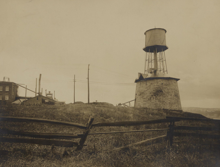
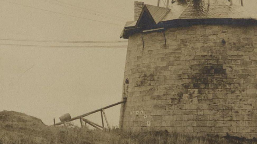
It is easy to understand Todd’s dismay at the condition of the towers in the early 1900s. As seen in the photograph, Martello Tower 1 is integrated into the industrial complex of the Ross Rifle Co. Factory, visible on the left. In fact, a water tower had been built on the roof of the Martello Tower to meet the factory’s operational needs. As Todd noted, the tower’s stonework still shows numerous impact marks. These may have been left by rifle bullets fired by factory employees around targets drawn on the tower’s north face. The Ross rifle was renowned for its high accuracy compared to other firearms of the era, so much so that it was adopted by the Canadian military as the standard service rifle for infantry during the First World War. However, the military abandoned the weapon in 1917, and the factory closed shortly thereafter. The factory buildings remained on the Plains until 1931, when they were demolished to make way for the city’s water reservoir. Built on this land between 1931 and 1933, the reservoir still supplies drinking water to much of downtown Québec today.
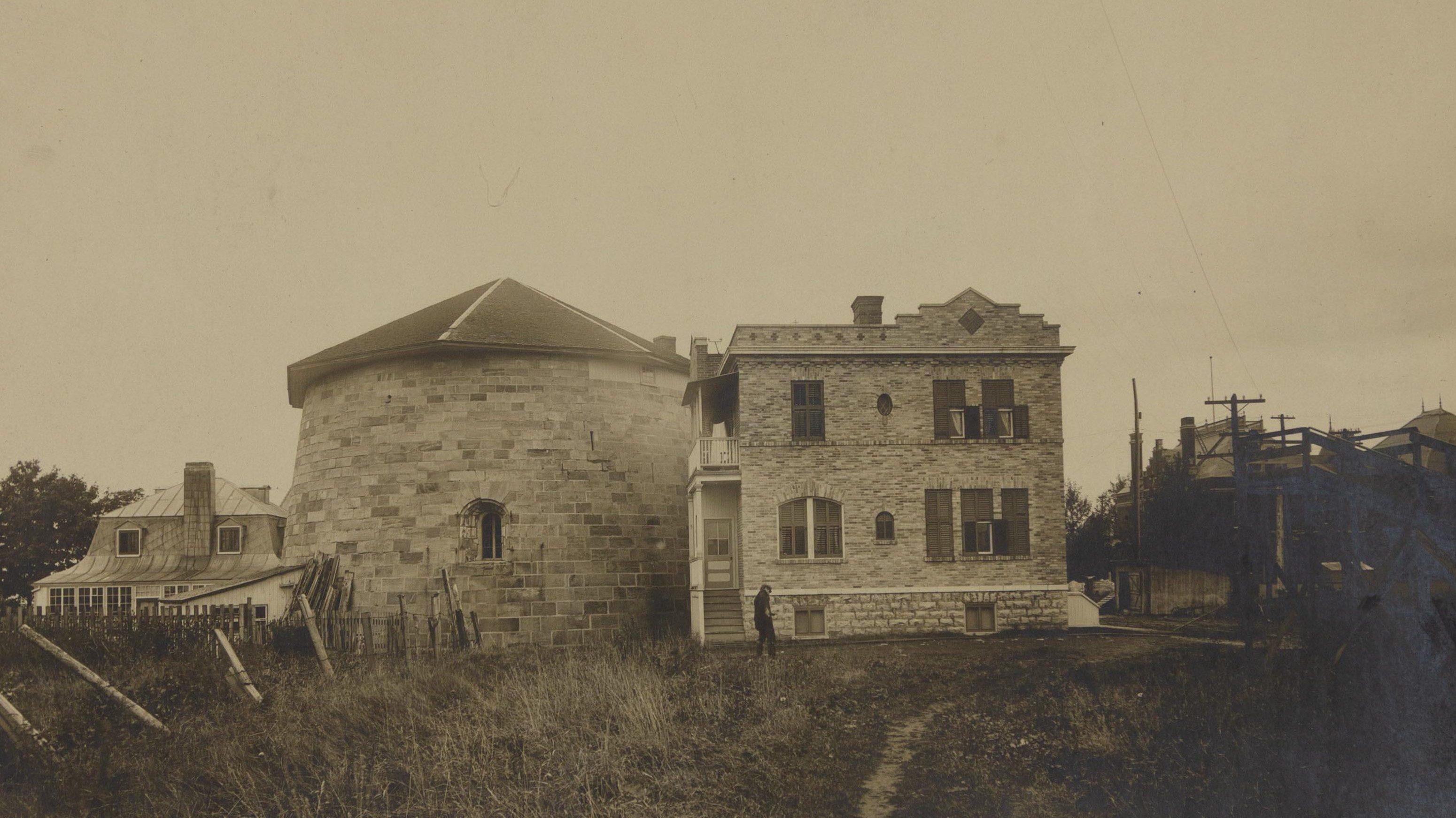
Located near Grande Allée, Martello Tower 2 was already surrounded by development in the early 20th century. Unlike Tower 1, however, it was not hemmed in by an industrial complex, and its structural integrity remained relatively secure. To its left in the photograph stands a house built in the late 1870s, which remains to this day, on a site where the British Army had planned advanced defensive works near the tower. On the right side, a residence adjoining the tower was built to hug its curved walls. This house was demolished in the first half of the 20th century. Larger than Tower 1, Martello Tower No. 2, along with Tower 3, formed the heart of the initial defence line designed by engineer Gother Mann. Tower 3, which is absent from the photos Todd used, had been considered obsolete and demolished in 1904 to make way for a new wing of the Jeffrey Hale Hospital, then located nearby. The creation of Battlefields Park ultimately preserved Québec City’s three remaining towers, including Martello Tower 4, which still stands today in the Saint-Jean-Baptiste neighbourhood.
The Québec Prison
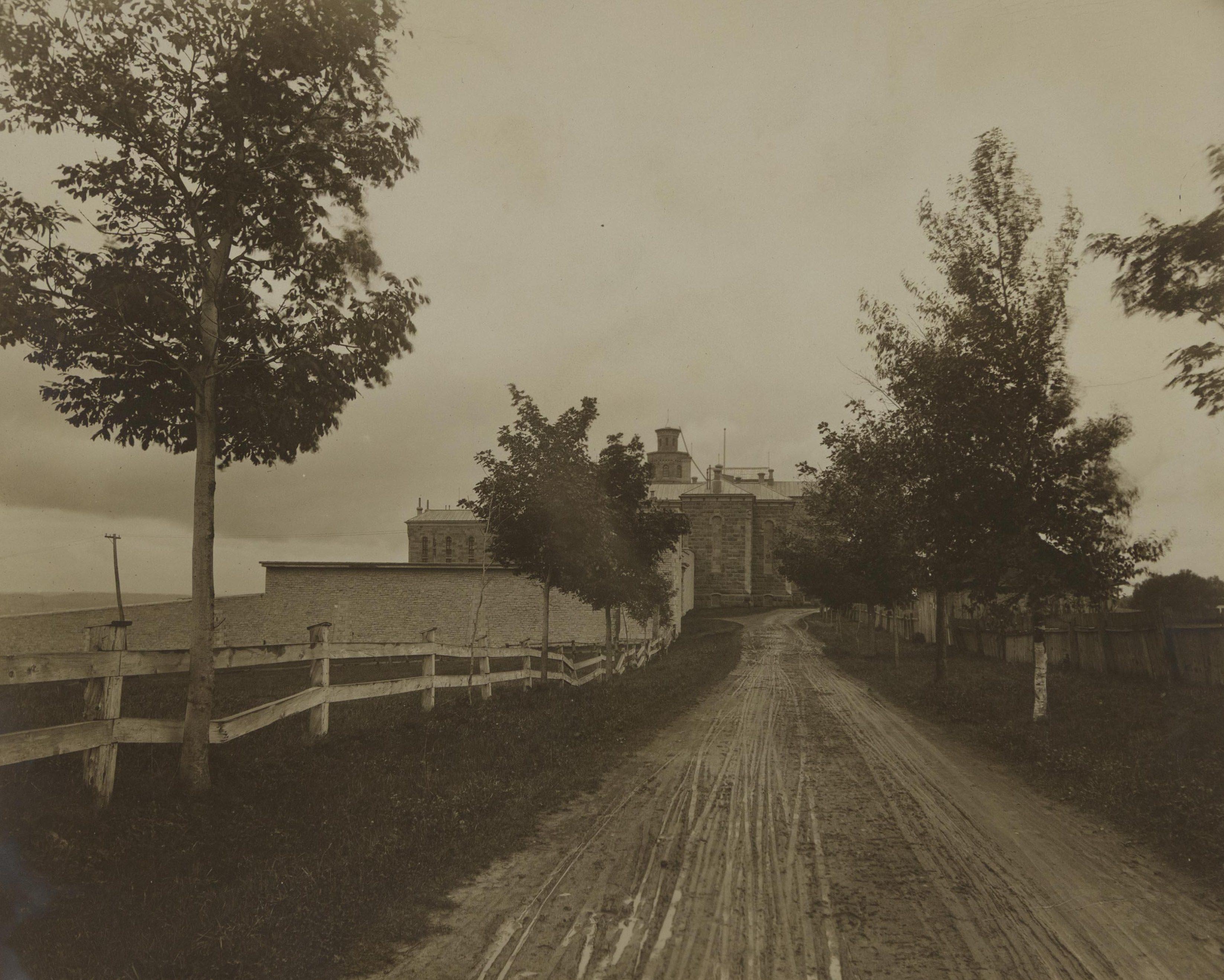
Todd noted that another massive building occupied the grounds of the future Battlefields Park: the second Québec Prison, which opened in 1867. It replaced the city’s first prison, located inside the fortifications, which today houses the Morrin Centre, a cultural hub for Québec City’s English-speaking community. Because the old prison was considered too small, too close to residential areas and connected to the vices and dangers of urban life, the city commissioned architect Charles Baillairgé to design a modern facility on the Plains of Abraham, outside the city walls. Baillairgé envisioned an imposing three-wing building inspired by the latest 19th-century penal practices. Only two of the three wings were ultimately built, and after a few years of operation, prison authorities added a perimeter wall to keep onlookers away from the yard, particularly during executions. The complex sat directly on an existing road at the start of the 20th century called Rue de la Tour. Todd quickly determined that he would need to alter the road planned for the park.
You will notice by referring to Photograph No. 6 is taken from the centre of Tower Street looking toward the Jail, that this is a very poor approach indeed to Wolfe’s monument. The street is laid out so that it appears to terminate in the blank wall of the Jail and it is necessary to squeeze by one corner of the Jail and then descend by a sharp grade to the monument, whereas, by diverting this drive as sown on the plan, this disagreeable feature is obviated, and a pleasing drive with an easy grade secured with an approach directly on the axis of the monument.
The monument Todd referred to is the Wolfe Monument, which marks the exact spot where General James Wolfe died on the morning of September 13, 1759, during the Battle of the Plains of Abraham. Since Todd aimed to create a historical and commemorative park, existing landmarks like this monument, along with the Des Braves Monument and the Martello Towers, had to feature prominently in the space. This focus even led him to propose ideas that have not been realized and will never be. For instance, he raised the possibility of reconstructing a temporary fortification hastily thrown up by the British in 1759:
The third and final post in this series will focus on the monuments, as well as Sainte-Foy’s park, known today as Des Braves Park.